Sunday 28 September 2008

Ekranoplans!


You can almost imagine Gerry Anderson making these things. Awesome, aint they!

I suppose they could do something to replace conventional aviation. I wonder if such an idea could... take off?

Sorry.

Anyway, the reason I've put this up is because there's one in google earth, on the edge of the Caspian Sea, in a place called Kaspiysk.

42°52'54.88"N, 47°39'24.52"E

Here's a piccie...

Sunday 21 September 2008

European Pollutant Emission Register

Clicking

this link

will add a layer to your google earth application, which details the emissions of over 11,000 european industrial sites. If you're concerned about the environment, this contains some useful figures.

Weirdness

What is this???

My guess is it's either some kind of vehicle test track or a race track. It's in the British Midlands, east and a bit south of Stratford upon Avon.

52°10'57.38"N, 1°30'0.63"W

Saturday 20 September 2008

L etc...

Did I ever tell you about the time I went to a peace camp?

No?

Well I was 16, so it must have been in April 1984. Radical times... Miners were striking. Marchers were marching. And there was something called the STAR march. STAR was an acronym for "Stop The Arms Race". I cycled from Wirral to Chester, then I marched from Chester to Shropshire Then I rode home again. The protest march went on much further, eventually all the way to Greenham Common in Berkshire.

A few days or weeks later (I don't remember exactly) I concieved the idea of cycling to a peace camp, and without telling my mum or dad, I got up before the sun one fine spring morning and went. My route was the A41. This used to be one of the longest roads in Britain, although now it is no longer contiguous. It's become the B4141 in parts, for example, and much of it has now been usurped by various by-passes and motorways, but at one time it ran all the way from Birkenhead to London.

So as a fit 16 year old, I cycled and I cycled and I cycled some more. My route took me from Neston to Chester to Malpas to Whitchurch to a tiny little place called Whixhall Moss, amidst the marshes and bogs of Western Shropshire. There I rested in a field. The next day I continued onwards and as night fell, I was passing through the southern part of the West Midlands conurbation, looking for somewhere to stop and sleep.

I went through Solihull and a Knowle before proceeding further south to banbury and eventually to my goal.

Near Knowle there is an "L" shaped building. Good enough.

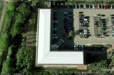
52°22'16.73"N, 1°47'56.84"W

South of Knowle the country starts to become more rural. By the time I got to a suitable field, it was very late, I'd been cycling all day, and I was as tired as I've ever been in my life. Too tired to put up a tent. So I just unruilled my sleeping bag and slept in it.

Bloody thing had frost on it the next morning. Jeez it was cold. Got warm though and got going.

The sun shone hot and strong once the early morning mist had burned off, and I got sunburned. This wasn't helped by the lack of panniers or anything. Everything was on my back in a big heavy rucksack. Every time I took it off it would sccrrapppee down my poor burned arms.

Eventually I got to the camp and had a lovely time for a few days, then I cycled all the way home again. Got back in two days. I couldn't do it now.

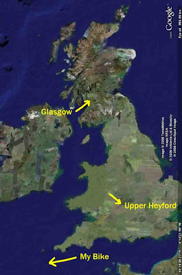
A couple of months later and I did the same thing again, only this time, an anarchist from Glasgow borrowed my bike and never brought it back.

Wanker.


This is what Upper Heyford looks like these days. 24 years ago there were F1-11's, B52's and C5's. Now it's just a bloody big car park.


The peace camp itself is just a tree lined track. It runs for a couple of hundred yards and then comes to an abrupt halt at a fence. A road to nowhere.

Oh yeah. I nearly forgot.

abcdefghijklmnopqrstuvwxyz
ABCDEFGHIJKLMNOPQRSTUVWXYZ
1234567890

Thursday 18 September 2008

Anglesey

I've been to Newborough today. (well yesterday now really)

It's a small town in the South West corner of Anglesey. To get there, we went through Star and Llandaniel Fab. I think they must have been where Austin Powers went on holiday.

To the south of the town, just by a roundabout, there's a café that sells these brilliant all day vegetarian breakfasts. Mmmmm!

But what I really went for was Llanddwyn Island.

The car park we'd parked in (near the ace café) was miles away. We'd have had to have walked about 10 miles with all the camera gear to get there and back, but the maps showed a closer car park, which we found after a couple of wrong turns.


Llanddwyn is beautiful, windswept, almost deserted. Covered in paths, and lots of signs advising you to stick to them. Church ruins. Old lighthouse. But what really stood out for me were some beautiful rocks in the cove on the southern tip of the island.


The picture doesn't really do the colours justice because the light was very flat. The sun stayed behind a bar of cloud that hovered, almost without moving, just above the horizon. We'd hoped for some sunshine so that we could use the situation towards my wife's university work, and the light was OK, but not brilliant, until right at the end.

We left the island and walked back along the beach, when suddenly we started to cast shadows. The sun had finally fallen beneath the cloud bar, and we got some lovely sunset shots in.

On the beach were trillions of tiny teeny little insects hopping around on the seaweed. I think they get their sustenance from it. Amazing sight, but you might feel a bit itchy if you don't like crawly things.


Llanddywyn is here:

53° 8'19.05"N, 4°24'37.84"W

According to google earth, the entire island has an altitude of 0 metres above sea level. My legs tell a different story.

Wednesday 10 September 2008

A New, Improved, X

I mean the old one, well, it's just an X painted on the floor to show the spaceships where to land or something. But I want to use things that aren't letters as letters if I can.

Welcome to Switzerland! Take a Swiss flag (it's the only square national flag by the way) and rotate it through 45°.

Now make it bigger. Much bigger.

That's what those crazy Swiss bods have done in Lausanne. Not content with almost destroying the world by creating a black hole, they've gone and made a bloody big red flag with a white cross in it.

No chance of them being bombed by mistake, that's for certain. Or is that the Red Cross?

As ever, the little link below will centre your google earth thing on it.

46°30'1.09"N, 6°28'54.44"E

abcdefghijklmnopqrstuvwxyz
ABCDEFGHIJKLMNOPQRSTUVWXYZ
1234567890

Thursday 4 September 2008

S

Well the "S" had to be good. I found a small S shaped slide at a German swimming pool the other week, but rejected is as too crap.

Yet the S is a useful letter to have here. So for now, I cheated. I did a google search for "S shaped building" and found a lovely one in Riyadh, Saudi Arabia. That's alright, isn't it? I mean, it's not like anybody's actually reading this or anything?


Of course, when I find a better one, I will replace this tainted, plagiarised S, but for now, it's just going to have to do.

This link will take you to it...


24°38'46.27"N, 46°42'6.69"E

abcdefghijklmnopqrstuvwxyz
ABCDEFGHIJKLMNOPQRSTUVWXYZ
1234567890

Wednesday 3 September 2008

D and swastikas

There's a swastika shaped building in a navy base in Coronado, California, that's created a bit of comment over the last year. It's actually 4 L shaped buildings, each at an angle of 90° to the next. The controversy has been well documented elsewhere. For more information do a search for "swastika shaped building" in the search engine of your choice.

A swastika, although very much a symbol, is not a letter or number. Here's what Kurt vonnegut had to say about it.

''Socialism''is no more an evil word than ''Christianity.'' Socialism no more prescribed Joseph Stalin and his secret police and shuttered churches than Christianity prescribed the Spanish Inquisition. Christianity and socialism alike, in fact, prescribe a society dedicated to the proposition that all men, women and children are created equal, and shalt not starve.

Adolf Hitler, incidentally, was a two-fer. He named his party the National Socialists, the Nazis. Hitler also had crosses painted on his tanks and airplanes. The swastika wasn’t a pagan symbol, as so many people believe. It was a working person’s Christian cross, made of axes, of tools.

About Stalin’s shuttered churches, and those in China today: Such suppression of religion was supposedly justified by Karl Marx’s statement that that ''religion is the opium of the people.'' Marx said that back in 1844, when opium and opium derivatives were the only effective painkillers anyone could take. Marx himself had taken them. He was grateful for the temporary relief they had given him. He was simply noticing, and surely not condemning, the fact that religion could also be comforting to those in economic or social distress. It was a casual truism, not a dictum.

When Marx wrote those words, by the way, we hadn’t even freed our slaves yet. Whom do you imagine was more pleasing in the eyes of a merciful God back then: Karl Marx or the United States of America?

Stalin was happy to take Marx’s truism as a decree, and Chinese tyrants as well, since it seemingly empowered them to put preachers out of business who might speak ill of them or their goals.

The same naval base contains two swimming pools. They could have formed an "i" shape for me, but I have a lovely "i" in the South Pacific already. The "." of the "i" is shaped like a "D", in a stylised, art decoish font.

So I can now make words like "DAViD" and "GiDDY" or even "ADDiTiVE"

Here's the link...

32°40'34.82"N, 117°10'13.95"W

abcdefghijklmnopqrstuvwxyz
ABCDEFGHIJKLMNOPQRSTUVWXYZ
1234567890

Tuesday 2 September 2008

uʍop ǝpısdn ƃuıʎlɟ

If you use the flight simulator, and just let the plane fly itself, it will eventually crash. It just does. It becomes unstable and eventually nosedives into the ground.

But there is a way around this. Here's how you do it...

1. Take off using the SR22.

2. Get up to a height of about 1500 to 2000 feet (about 500-700 metres.)

3. Put the plane into a nosedive. The Elevator setting should be just a little bit away from right up to the top of the slider.

4. Well that's all really. Make sure the plane is at full power, that the controls are centred, the landing gear is up and the flaps are at 0% and do nothing.

The plane will do an upside down loop and will fall away to one side, but all the time it will become slightly higher and slightly steadier. Eventually it will fly upside down and very slowly gain altitude. The propellor plane will max out at just a shade under 25,000 feet.

Despite you pointing it in a straight line, it will actually travel in a huge circle. Since it doesn't really exist, it doesn't use any fuel, and so you can leave it for hours or days or weeks, and because it goes slowly around in a miles wide loop, it will still be more-or-less in the vicinity of where you left it. Handy if you need it in a hurry.

By the way, if you're wondering how I managed to write "uʍop ǝpısdn ƃuıʎlɟ", it's because of this neat little website...

http://www.revfad.com/flip.html

Monday 1 September 2008

8

I keep finding them! These numbers and letters keep on appearing. But I'm having to work quite hard to find quality examples.

Today I have none, but fortunately, I had something in reserve. A day when I found lots but didn't use them all. I kept my powder dry. I didn't give away the goods too soon.

And now I can reap the rewards of my prudence. Today's the day when I give to you, dear reader, the number "8"

As with all the symbols I'm collecting, it's not directly an 8. I could find all the numbers and letters quite easily just be looking for road markings or helipads or whatever. Indeed this 8 does have a perfectly good "H" inside it, which I will not be using. It forms a near right angle when lined up with the locations of my "Q" and my "T". Spooky huh? Never mind leylines. My alphanumeric symbols will spell out the Truth and we will all be saved. Maybe.

The BBC's postcode used to be W12 8QT. Coincidence?

Nope. Totally contrived. By me.

Anyway... the "8". Here it is.

It's just to the South of Chester, England; close to a small Cheshire village called Boughton Heath, and just to the south of the A55.

53°10'13.17"N, 2°51'28.28"W

I think it's an old army camp or something, so perhaps it was formed by the boots of hundreds of men marching round and round in circles.

abcdefghijklmnopqrstuvwxyz
ABCDEFGHIJKLMNOPQRSTUVWXYZ
1234567890