I've always been a reader, ever since I was a small child. My mum reckons I could read upside down when I was six years old. I put that down to being left handed. Or possibly to being upside down.
I do want to use this space to post a brief review or crit of whatever it is I happen to be reading right now. That's not as straightforward as it should be though, because for me, reading books isn't a strictly linear finish-one-start-another process. Nor are all of the books made of paper and ink. For example, I've been listening to a couple of audiobooks lately. They are "The Handmaid's tale" by Margaret Attwood, "The Life of Pi" by Yann Martell, and "Transition" by Iain (M) Banks. They typically form part of my driving soundtrack, particularly if I'm on a long journey, and I'm alone in the car.
What "Real" books get read depends on where I am and what I'm doing. Beside my bed I have a stack of books. Actually, "stack" gives too much of a sense of order. Beside my bed I have a jumble of books. Some read, some partly read. Some waiting to be read. I can't even say what they all are off the top of my head. I have just finished "Lord Foul's Bane", the first part of the first trilogy of Thomas Covenant, by Steven Donaldson. This is something I read about 20 years ago. I feel the same way about it now as I did then.
Donaldson handles the fantasy elements really well, although his protagonist is frequently infuriating. The bits of the book that are set in the "real" world are horribly stilted. They grate enormously, and I had to force my way through the first couple of chapters until Covenant stood atop Kevin's Watch, with his legs turning to jelly with vertigo and disorientation. It's got a lot in common with the Lord of the Rings trilogy, in that it's a black and white struggle between good and evil. And it's got a ring of power in it. And a map, which bears some resemblence to Middle Earth. There are places in Donaldon's Land that could be seen as analogues to locations in Middle Earth. Andelain is Lorien. Gravin Threndor/Mount Thunder is Mount Doom. the Characters too are of a familiar type. Lord Foul is Sauron. Lord Mhoram is the Hero Figure. Aragorn, but more complex. Covenant himself saves the book from being a straightforward monomyth.
I suppose I should read part 2 now, but I have other books that I want to get my teeth into. Jared Diamond's "The Third Chimpanzee" is gathering dust waiting for me to read it. George Monbiot's "Captive State" lies half read and ignored. I got very bored with it, I must admit. It is a few years old now, and the issues are well known to me. I've also got a book about space exploration winging it's way across the Atlantic as I type. I'd expect that to be here within a week or so.
There's also the toilet book.
Traditionally, in our lavvy, we have reading material that can be perused for brief satisfying periods of just a few minutes. One good one was an art book called "The Art of Looking Sideways". A recent one was a series of short essays and newspaper columns by Sandi Toksvig. It had it's moments but I wouldn't eat laxatives just so that I could go read it or anything.
Currently, Douglas Adams' "The restaurant at the end of the Universe" resides in the bathroom. I've read it to bits, and whatever random page I open it up at, it's too familiar, but I haven't got round to returning it to the bookshelf yet.
Fortunately, there's also a book of Calvin and Hobbes cartoon strips to read. Now they're excellent. I find myself linering far longer than I need to.
Friday 26 February 2010
Thursday 25 February 2010
Solar power and space elevators
A space elevator is basically a satellite with a string attaching it to the Earth. Centrifugal force from the Earth's rotation makes what ever is on the end of the string want to move away from the Earth, but the line tethers it. You can then attach a climbing machine to the line and have it go up and down to the satellite. It's a well established idea in theory, but we're waiting for materials technology to provide something that is both strong enough and light enough to serve as a line.
http://en.wikipedia.org/wiki/Space_elevator
But such a line need not only be a rope. It could also be a power cable. I reckon we could put some great big solar panels up in orbit, and send the power down the line. Put it far enough away from the planet, and the amount of sunlight reaching the surface of the world would not really be affected.
Just a thought. I doubt if I'm the only one to have thought it.
Wednesday 24 February 2010
Abandonware
Computer games have been around for a few years now. Like anything else, they have a shelf life. They get superceded, or the system you're using changes from a zx81 to an Amiga to a PC.
But should you have a hankering for the good old days when you spent hours typing "Go west and pick up knife" or whatever, it's possible to get hold of PC versions of many of these old games.
The developers have recouped their costs. Or if they haven't, nobody's going to bother paying for their 20 year old code. So it's possible to find sites that will allow you to download playable games free of charge.
I'm busy playing speedball 2 right now. Management mode, so that I don't have to wreck my keyboard or strain my ageing fingers.
The best site I've found for this is called Abandonia. There are others. I use to use Home Of The Underdogs, but that used to be plagued with popups and spyware.
Monday 22 February 2010
All the fun of the fair
Just a quick one... (if you can do anything quickly on blogger at the moment)
This...

Is a part of Wallasey Docks. To the right is a type of bridge called a rolling bascule bridge. Basically, a curved rack and pinion with a counterweight, and the leaf of the bridge carries a roadway over a lock of a dock. When a ship comes, they use an electric motor to move the rack and pinion - lowering the counterweight and raising the bridge. Centre left is a rusty old German U-Boat. That's now gone to Woodside Ferry Terminal in Birkenhead, about a mile down the road. Between them are a couple of warehouses. The image is dated March 2007, and those warehouses have now been demolished.
For the last couple of weeks, the bare land has been occupied by a fairground. This finished today, so we thought we'd go and take some photographs. I was hoping the darkness, and a long shutter time would give some interesting result, as many of the attractions were chucking people around. Sadly, a bit more care was needed, like taking a tripod, but it was a spur of the moment thing and we just grabbed our cameras and went.
Here are some of the better ones...
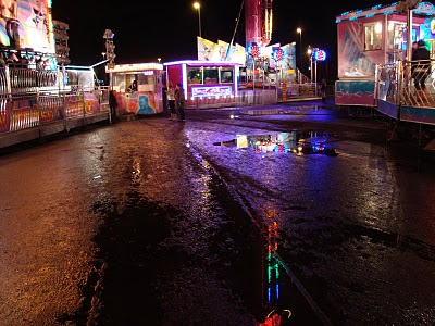
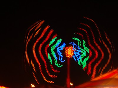
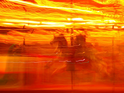
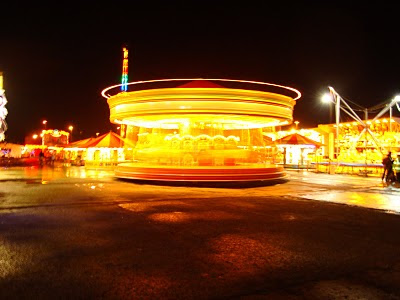
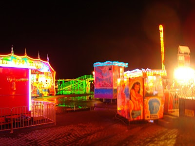
Gaudy or what!
This...

Is a part of Wallasey Docks. To the right is a type of bridge called a rolling bascule bridge. Basically, a curved rack and pinion with a counterweight, and the leaf of the bridge carries a roadway over a lock of a dock. When a ship comes, they use an electric motor to move the rack and pinion - lowering the counterweight and raising the bridge. Centre left is a rusty old German U-Boat. That's now gone to Woodside Ferry Terminal in Birkenhead, about a mile down the road. Between them are a couple of warehouses. The image is dated March 2007, and those warehouses have now been demolished.
For the last couple of weeks, the bare land has been occupied by a fairground. This finished today, so we thought we'd go and take some photographs. I was hoping the darkness, and a long shutter time would give some interesting result, as many of the attractions were chucking people around. Sadly, a bit more care was needed, like taking a tripod, but it was a spur of the moment thing and we just grabbed our cameras and went.
Here are some of the better ones...


Gaudy or what!
Saturday 20 February 2010
Blogger is very slow for me right now.
Sometimes the connection times out. Sometimes I can come back to a page I've initiated after a few minutes to find it's sorted itself out. Like now, when I've clicked "sign in" and "new post".
Trouble is, I've forgotten what I wanted to say.
Most of my site traffic is still looking for triple breasted women, although a few people have popped in to look at my picture of the middle of the atlantic ocean.
Welcome! If you were looking for wanking material, sorry to disappoint you. How anyone could get off on a picture of an empty ocean is beyond me, but whatever floats your boat...
Did you like that? It's a pun, you see.
Ocean.
Floats your boat.
Ah well, never mind.
I'm wondering if I can add alt tags to my pictures. On my desktop computer, sitting unused and unloved upstairs, I have dreamweaver, and could easily do a post and copy/paste the code over into blogger. But the laptop is so much more convenient, and stops me skulking in my little cave.
I could vastly increase the number of hits my site gets if I alt tagged all my pictures with naughty words.
So let's try it. (waits for 5 minutes for upload image page to display something useful...)
(still waiting...)
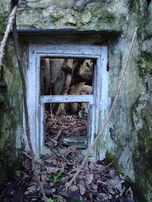
Aha! The Alt tag is already embedded into the code, but as a null string ("")
So all I should have to do is put whatever obscene perversion I like between the quotes. So here goes. If this works, right clicking your mouse over the picture of the window of a derelict cottage and selecting "properties" should bring up a the words "nicholas winterton's willy"
If you do a google image search for this term in a week or two, you might well find the picture above.
Please note: I am in no way trying to imply that Nicholas Winterton's willy looks anything like the window of a derelict cottage. It was just the first expletive that popped into my head.
Wednesday 17 February 2010
Walking for fitness and pleasure.
I'm getting a bit of a belly on me.
A combination of a sedentary job, followed by evenings spent surfing the net, and an unhealthy diet are causing me to gain weight. Or to be more precise, mass.
The diet never used to be a problem (at least not to my body mass index. I'm sure my arteries are furring up nicely.) because I used to cycle and walk everywhere.
I've always enjoyed the great outdoors. I love wildernesses as long as theyr'e relatively free of tigers, mosquitoes and nettles. And wasps. So today, being a day without any work to do, I went for a walk.
I was going to go to the Deeside marshes and walk down to Burton Point, but that's dodgy ground these days. Has been for quite a few years in fact. You used to be able to drive along this narrow, rutted little road. Covered in weeds and sheep shit, it was. But it ran right next to an army firing range. They closed the road off about 15 years ago, although I suppose you could climb over the fence and walk along it. I suspect there's even more weeds and sheepshit now. When I first got wheels, in my mid 20's, I'd be down there regularly, whizzing along over the cattle grids, listening to mix tapes and getting stoned.
Back to the present day though, and rather than risk getting shot or told off or arrested, I looked for somewhere better, on Google Earth, and found the old fun ship near Mostyn on the Flintshire coast. That lies next to a public footpath that runs alongside the Dee estuary.
Bingo!
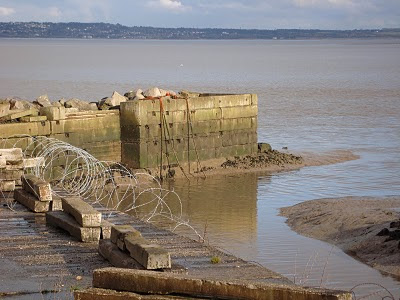
The path has to leave the riverside after a mile or so, because industry intervenes. There's a wind turbine factory, and there's a dock that takes Airbus A380 wings from the barges that brought them from Broughton, and takes them to Toulouse in France. So that's as far as we went.
Some pictures:
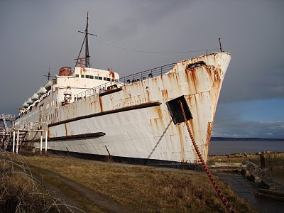
This is the "Fun Ship". It's as much fun as standing on a rake. It used to be a ferry, then it got dragged up onto the beach here and turned into an amusement arcade. Now it's used as storage space and it's closed to the public. They are warned of dogs and landmines and the threat of prosecution. Probably best not to try to get in. Fair enough. I can see the vandals would have a field day with it. It's looking more and more decrepit as the years go by, but I'm told it's quite nice inside.
When I took this picture, the late afternoon sunshine was reflecting off the water, and making pretty patterns on the wall. It doesn't show up too well on a still picture though. Never mind. It does give an accurate picture of what the banks of the Dee Estuary are like. The brown stuff is soft thick mud. Ideal for oystercatchers and herons. Not so good for drunks.

This is what the West coast of the Wirral looks like from the Welsh side of the Dee. The line of white buildings towards the right of the picture is a place called Parkgate. They're famous for their icecream.
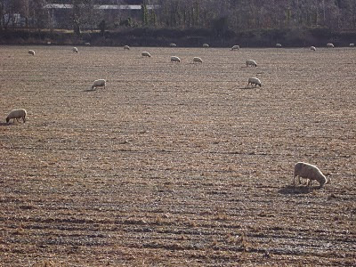
Sheep. Eating gravel and sawdust. There was a perfectly green and grassy field just a few hundred yards away, but they chose, of their own volition to graze here.
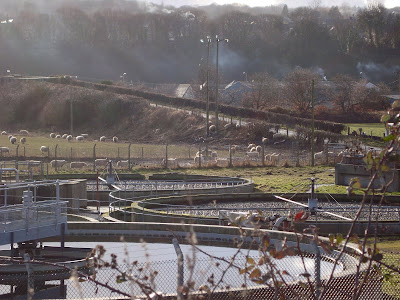
A sewage treatment plant. There are quite a few of these along both banks of the Dee. It didn't smell at all. Birds were feeding off insects on the filter beds, although they kept getting disturbed by the rotary sprayer thing.
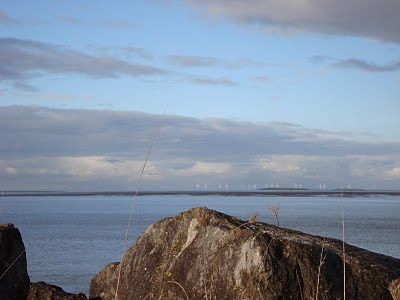
In the distance, you can see Hilbre island. It's pronounced "Hill-Bree" and it lies about a mile off the coast of Wirral. My Mum got stranded on it once. She made the BBC news! Behind Hilbre, there's a big load of wind turbines. They're Burbo Bank wind farm and they generate enough energy to power 80,000 homes, although I suppose if everyone plugged their car into a wall socket, this number would shrink somewhat.
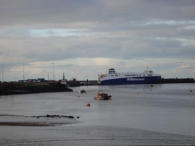
The ship that takes the wings of the worlds largest passenger plane to France. And this is as far as we went.
Coming back we saw an incredible sight. There was a huge white cloud boiling up from beyond Wirral. It was coming from Fiddler's Ferry power station. This generates a little over twice what the wind farm generates, but nowhere near as cleanly. Water vapour is itself a greenhouse gas. Putting bloody great clouds into the sky can't be good. I say bollocks to the nimbies. Build turbines. Lots of them.
Sadly, my camera stopped taking pictures. I tried several times but it just wouldn't click it's shutter. I blamed the battery and gave up in disgust.
I found later that I'd somehow moved the dial to video. So here's a short video of the cloud generated by a coal fired power station about 20 miles away.
A combination of a sedentary job, followed by evenings spent surfing the net, and an unhealthy diet are causing me to gain weight. Or to be more precise, mass.
The diet never used to be a problem (at least not to my body mass index. I'm sure my arteries are furring up nicely.) because I used to cycle and walk everywhere.
I've always enjoyed the great outdoors. I love wildernesses as long as theyr'e relatively free of tigers, mosquitoes and nettles. And wasps. So today, being a day without any work to do, I went for a walk.
I was going to go to the Deeside marshes and walk down to Burton Point, but that's dodgy ground these days. Has been for quite a few years in fact. You used to be able to drive along this narrow, rutted little road. Covered in weeds and sheep shit, it was. But it ran right next to an army firing range. They closed the road off about 15 years ago, although I suppose you could climb over the fence and walk along it. I suspect there's even more weeds and sheepshit now. When I first got wheels, in my mid 20's, I'd be down there regularly, whizzing along over the cattle grids, listening to mix tapes and getting stoned.
Back to the present day though, and rather than risk getting shot or told off or arrested, I looked for somewhere better, on Google Earth, and found the old fun ship near Mostyn on the Flintshire coast. That lies next to a public footpath that runs alongside the Dee estuary.
Bingo!
The path has to leave the riverside after a mile or so, because industry intervenes. There's a wind turbine factory, and there's a dock that takes Airbus A380 wings from the barges that brought them from Broughton, and takes them to Toulouse in France. So that's as far as we went.
Some pictures:

This is the "Fun Ship". It's as much fun as standing on a rake. It used to be a ferry, then it got dragged up onto the beach here and turned into an amusement arcade. Now it's used as storage space and it's closed to the public. They are warned of dogs and landmines and the threat of prosecution. Probably best not to try to get in. Fair enough. I can see the vandals would have a field day with it. It's looking more and more decrepit as the years go by, but I'm told it's quite nice inside.

When I took this picture, the late afternoon sunshine was reflecting off the water, and making pretty patterns on the wall. It doesn't show up too well on a still picture though. Never mind. It does give an accurate picture of what the banks of the Dee Estuary are like. The brown stuff is soft thick mud. Ideal for oystercatchers and herons. Not so good for drunks.

This is what the West coast of the Wirral looks like from the Welsh side of the Dee. The line of white buildings towards the right of the picture is a place called Parkgate. They're famous for their icecream.

Sheep. Eating gravel and sawdust. There was a perfectly green and grassy field just a few hundred yards away, but they chose, of their own volition to graze here.

A sewage treatment plant. There are quite a few of these along both banks of the Dee. It didn't smell at all. Birds were feeding off insects on the filter beds, although they kept getting disturbed by the rotary sprayer thing.

In the distance, you can see Hilbre island. It's pronounced "Hill-Bree" and it lies about a mile off the coast of Wirral. My Mum got stranded on it once. She made the BBC news! Behind Hilbre, there's a big load of wind turbines. They're Burbo Bank wind farm and they generate enough energy to power 80,000 homes, although I suppose if everyone plugged their car into a wall socket, this number would shrink somewhat.

The ship that takes the wings of the worlds largest passenger plane to France. And this is as far as we went.
Coming back we saw an incredible sight. There was a huge white cloud boiling up from beyond Wirral. It was coming from Fiddler's Ferry power station. This generates a little over twice what the wind farm generates, but nowhere near as cleanly. Water vapour is itself a greenhouse gas. Putting bloody great clouds into the sky can't be good. I say bollocks to the nimbies. Build turbines. Lots of them.
Sadly, my camera stopped taking pictures. I tried several times but it just wouldn't click it's shutter. I blamed the battery and gave up in disgust.
I found later that I'd somehow moved the dial to video. So here's a short video of the cloud generated by a coal fired power station about 20 miles away.
Sunday 7 February 2010
Fog Blog
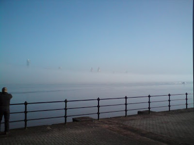
I was taking Bren to Birkenhead this afternoon, and it was a bit misty. As we got to Seacombe Ferry, we found that a bank of fog was lying over the Mersey, and the newly constructed hi rise towers of the Liverpool skyline were poking up above it. A rare and beautiful site!
We nearly always have a camera with us, but not this time. All we had was the built in camera on Bren's phone. We stopped and she took one quick shot, and couldn't even really compose the picture.
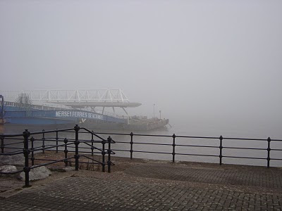
When I'd dropped her off, I collected my camera, and went back to the ferry terminal, but the fog had closed right in, and you couldn't see to the middle of the river, never mind the buildings on the opposite bank.
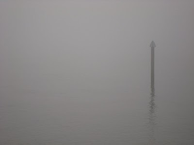
This has a beauty of it's own of course. Later on, I was teaching someone how to drive in the fog. The sun was going down over the Welsh hills, and there were some beautiful sights to see, but I couldn't take photographs because we were doing 50 miles an hour. I did stop at one point and take one down on New Brighton promenade.
Visibility was down to, what? 100 meters?
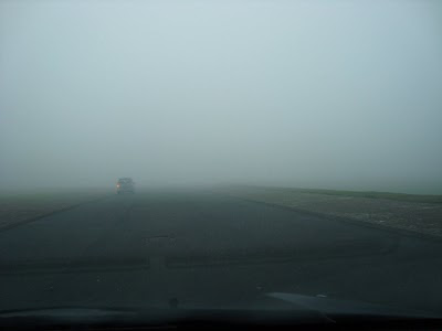
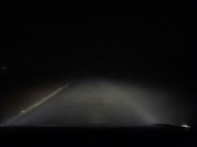
It got worse. Much worse. I'm actually lost at the moment. I'm typing this from my laptop with a mobile broadband connection. Somewhere in the distance, a dog is barking. Perhaps if anyone recognises where I am, they can post a message and let me know. Here's a picture.
None of the above photographic missed opportunities come as a surprise. This is nothing new for us.
Once upon a time, a few years ago, we were driving home along the prom, in thick November fog. There was a circus, and it's coloured lights loomed out of the mist. It would have made an amazing picture, but we never went back, and we've always regretted it.
We nearly always have a camera with us, but not this time. All we had was the built in camera on Bren's phone. We stopped and she took one quick shot, and couldn't even really compose the picture.

When I'd dropped her off, I collected my camera, and went back to the ferry terminal, but the fog had closed right in, and you couldn't see to the middle of the river, never mind the buildings on the opposite bank.


This has a beauty of it's own of course. Later on, I was teaching someone how to drive in the fog. The sun was going down over the Welsh hills, and there were some beautiful sights to see, but I couldn't take photographs because we were doing 50 miles an hour. I did stop at one point and take one down on New Brighton promenade.

Visibility was down to, what? 100 meters?
It got worse. Much worse. I'm actually lost at the moment. I'm typing this from my laptop with a mobile broadband connection. Somewhere in the distance, a dog is barking. Perhaps if anyone recognises where I am, they can post a message and let me know. Here's a picture.

None of the above photographic missed opportunities come as a surprise. This is nothing new for us.
Once upon a time, a few years ago, we were driving home along the prom, in thick November fog. There was a circus, and it's coloured lights loomed out of the mist. It would have made an amazing picture, but we never went back, and we've always regretted it.
Friday 5 February 2010
Soundtrack to the demolition of the Earth
Surfing away, as you do...
Well they've certainly gone up in my estimation. I always assumed it was an in-house thing.
Well they've certainly gone up in my estimation. I always assumed it was an in-house thing.
Wednesday 3 February 2010
Middle Earth
I can't find Mordor on Google Earth, no matter how hard I look. GE would have been handy for the company of the ring I reckon.
Tolkien either set or continued a trend for giving his settings a map. I'm reading a fantasy book at the moment, and it's extremely derivative, right down to it's map.
Here's a version of Tolkien's world. The person that drew it has seen fit to add distances in the top left hand corner.
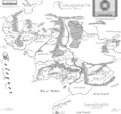
Fantasy writers seem to like the "League" as a unit of linear measurement. This allows them considerable scope, since you can't pin one down to any particular distance.
"The distance a man can walk in about an hour" is one description. That's about 3 miles. But if Fred Bloggs, author, says that Grebbo the Great marched his men 20 leagues in a day, he could rebut charges of cruelty by pointing out that he didn't have the men walk 60 miles, because he used the measurement from Ancient Rome. That's about 1.4 miles. So the men walked a mere 28 miles. And Grebbo bought them all ice creams.
Tolkien's Middle Earth took several months to cross, on foot, with diversions and digressions. Farting about in Lorien and Rivendell. Getting stuck in Forests and Barrows. Going too far south into Emyn Arnen. That kind of thing.
I don't remember the exact text, and I have no intention of looking it up, but at one point, some of the company get from Cair Andros to Fangorn in 3 days. A distance that an awestruck man of Rohan described as 80 leagues, or something similar.
According to the person that did the map above, the distance from Cair Andros to Fangorn is about 200 miles. So they must have done about 66.66666 miles per day. That's a fairly constant 4 miles per hour (a fast walk) for 16 hours a day.
Kind of fits the text. The poor buggers must have been knackered, but your average triathlete would laugh scornfully at them and say "Strider? You're taking the piss, mate."
So that kind of puts a scale on things. But how did it come to be as it looks? What always struck me when I looked at Tolkien's map was the mountain ranges, and how they formed neat fences around certain areas.
Mountain ranges form through vulcanism, or through tectonic plate movement. They then slowly erode again.
In this case, I'd say three plates are converging. To the west there's Eriador. It's gradually colliding with Rhovanion to the east. Meanwhile, a southern plate containing Gondor and Mordor is moving northwards, and the uplift is forming the range known as the White Mountains.
the picture is complicated by vulcanism, particularly in Mordor. The lonely mountain, where Bilbo got the better of Smaug the dragon, stands alone. A purely volcanic formation.
I'd say it's likely that the Misty Mountains in particular are subject to seismic activity, and that therefore the mines of Moria are not a good place to try to set up home.
The Sea of Rhun is almost certainly hyper-saline, although if it's from a high latitude, the rate of evaporation is likely to be lower than similar lakes in warmer climates. It's mid-continental location means it's likely to be extremely cold during the winter, and hot and dry during the summer.
Left to it's own devices, nature tends to go through a series of colonising ecosystems, which culminate in a stable forested state. With the exception of isolated pockets in places like the Shire, Minas Tirith, Isengard, etc, the population density seems extremely low. If nobody is cutting down the trees or clearing the land, why are the forests limited to such a small area?
Perhaps poor soils are responsible. Or perhaps it's because it's not real. It's a modern myth. Or because it's actually New Zealand.
Subscribe to:
Posts (Atom)